As Azerbaijanis approach the 90th anniversary of the establishment of the Azerbaijan Democratic Republic (ADR) on May 28th, they are taking pride in the fact that their forefathers were the first in the entire Muslim world to launch a secular newspaper, a modern theater and opera, and a democratic state in which women were given the right to vote. But they are also thinking about that republic’s experience with defining its territory and establishing its borders, reflections that could have an impact on Baku’s policies in the future.
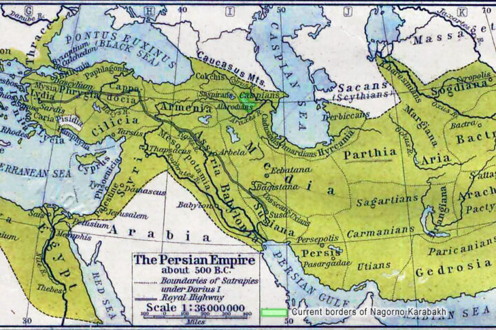
From the first day of its existence, the ADR had to deal with territorial claims from neighboring states. Indeed, these contested territories, which amounted to 114 000 square kilometers, were larger than its core uncontested area, 98 000 square kilometers. But after the Bolshevik invasion in April 1920 and the suppression of the ADR, Soviet Azerbaijan was able to keep only 86 600 square kilometers, a smaller territory than the uncontested one it had prior to that time.
Not surprisingly, and particularly given continued Armenian claims to Azerbaijani territory, many Azerbaijanis are focusing again on what happened in the period between the collapse of the Russian Empire which resulted in the independence of the ADR and the inclusion of a newly defined Azerbaijan SSR within the Soviet system. The history of this question is complicated and for various political reasons has frequently been distorted. But the basic facts are clear.
In May 1918, after the collapse of the Zakavkaskiy Seym, when the territories of the South Caucasus were moving toward full independent statehood, Azerbaijan agreed to yield Irevan (today known as Yerevan), a historically Azerbaijani city, to Armenia whose National Council argued that without Yerevan, Armenia would not have a real capital. In exchange, it agreed to drop all its claims on the mountainous section of Yelizavetpol gubernia (around Ganja).
When the Russian Empire conquered the Irevan khanate in the early 19th century, that area was populated primarily by “Turks,” as the Azerbaijanis in that region were known at the time. According to one 1901 study, there were 49 875 Muslims (primarily Turks) and 20 073 Armenians at the time of the conquest. [1] Another Russian scholar concluded that the Armenian Province created by the tsar after the conquest had a population that was three-quarters Muslim and only one-quarter Armenian (Potto, p. 595).
That territory, the first created along ethnicity, left its titular nationality, the Armenians, in a minority. And in 1849, the tsarist government abolished it, putting in its place the non-ethnically-defined Irevan gubernia. Despite massive immigration of Armenians from the Ottoman Empire and Persia subsequently, the Muslims, that is, the Turks, that is, the Azerbaijanis, retained a majority throughout the imperial period, and it were ethnic Azerbaijanis who represented the gubernia in the State Duma beginning in 1906.
Nonetheless, on May 29, 1918, the ADR conceded that city to the Armenians, arguing that this was “a necessary evil” under the circumstances and pointing out that even with that grant, Armenia would remain a tiny country, with a territory of only 9 800 square kilometers, far smaller than Azerbaijan.
One region in the South Caucasus where dramatic changes in the ethnic composition of the population had begun even earlier was Karabakh. In none of the early 19th century treaties or decrees pertaining to this region is there a single reference to the presence of Armenians there. But after the Russian conquest, tsarist officials began to resettle Armenian immigrants from Persia and the Ottoman Empire in the Muslim provinces of the South Caucasus, including Karabakh. The first group of five thousand Armenian families arrived in Karabakh in March 1828, Potto reports, largely because the Armenian Province, their initial destination, was suffering from a drought (Potto, p. 591).
Later, even larger groups of Armenians arrived and chose to settle there. In 1854, Prince Mikhail Vorontsov, the Russian viceroy, pointedly observed that “Armenians will always be indebted to us for everything they have; they are loyal everywhere and are obliged to serve us.” [2]
With the establishment of ADR, Azerbaijan reestablished its sovereignty over both the lowland and mountainous sections of Karabakh, something that the Armenian community acknowledged in a resolution of loyalty to Baku adopted at a congress which took place in that region during the summer of 1919. A.M. Topchubashov, the head of the Azerbaijani delegation to the Paris Peace Conference, pointed this out in a note distributed there. “Representatives of the Armenian population of Karabakh,” the note read, “have adopted a decision subordinating their population to the Azerbaijani government.” [3] But following the Soviet occupation of the South Caucasus, Moscow ignored this and made Karabakh an autonomous region within Azerbaijan, a step that was to prove so fateful later.
There is an equally important history concerning Nakhchivan. When the Russian Empire moved into that area, it was overwhelmingly Turkic (Azerbaijani). And even with the departure of many Muslims to Persia and the Ottoman Empire, there were still 17 138 followers of Islam as compared to only 2 690 Armenians. Following the collapse of the tsarist regime, Armenian forces drove more than 120 000 Muslims out of Zangezur, but these forces were not able to penetrate Nakhchivan or change the ethnic mix there to any significant degree.
An American plan to create a general governorship in Nakhchivan and Sharur in 1919 failed to materialize, and the ADR government did everything it could to defend the region. The Soviet authorities acknowledged this when on March 1, 1921, on the eve of the Soviet-Turkish treaty, a document among those in Lenin’s secretariat noted that Turks (that is, Azerbaijanis) and not Armenians were the dominant populations in Nakhchivan and Sharur, and that in most parts of these regions there was not a single Armenian living there at that time. [4] The Moscow and Kars treaties concluded in 1921 confirmed Nakhchivan’s belonging to Azerbaijan. That said, from the days of ADR’s establishment until Armenia’s sovietization in 1920, the border between Azerbaijan and Armenian run through the mid-point of Lake Goycha.
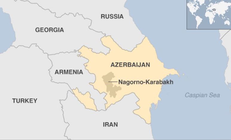
That means, of course, that the Mehri corridor that now separates Nakhchivan from Azerbaijan proper did not exist, but after the Soviet authorities absorbed both Armenia and Azerbaijan, they created it, thus establishing yet another neuralgic problem that continues to agitate the entire reigon.
Reference
Потто, Василий (1993). Кавказская война (в 5-ти томах), том 3, Ставрополь: Кавказский край.
Notes
[1] Гражданское управление Закавказьем от присоединения Грузии до наместничества Великого Князя Михаила Николаевича, Тифлис, 1901, с. 229.
[2] Акты Кавказской Археологической Комиссии [Acts of Caucasian Archaeological Commission], том 10, № 71.
[3] National Archive of Azerbaijan Republic [in Azerbaijani], stock 970, list 1, file 142, p. 77.
[4] Российский Государственный Архив Социально-Политической Истории [Russian National Archive of Social-Political History], фонд 5, список 1, дело 2796, с. 4.